Of the four days in the East, we spent three days driving up and down the coastal highway. These days were filled with stopping at ocean viewpoints, exploring the shoreline’s rugged geoparks, and learning about local indigenous culture. But as we navigated through this narrow stretch of land, sandwiched between the ocean and the mountains, we wondered what the landscape was like on the other side of the mountains. And we had exactly one day to find out what the East Rift Valley was about.
The alarm clock went off at 5:45 a.m. With only ten hours of daylight, we had a lot of ground to cover. We grabbed a quick breakfast, and off we went. As we drove out of Hualien, on the outskirts of the city, we saw probably the most unusual Starbucks, made from used shipping containers.
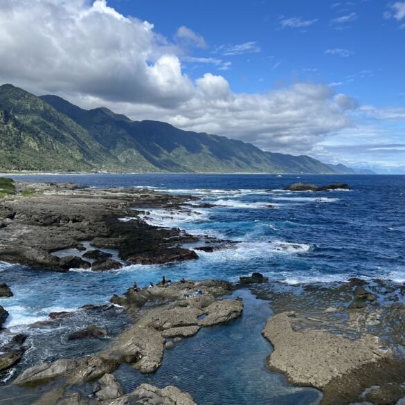
The East Rift Valley is a long basin located between two mountain ranges. On the map, it looked very narrow. We expected that driving would be like traveling along the coastal road, where we navigated between two clear geographic boundaries: the ocean and the mountains. But surprisingly, driving in the valley didn’t feel very claustrophobic.
If the coastal area had very little evidence of agricultural production, the East Rift Valley was the opposite. Known as Emerald Paradise for its lush greenery and the abundance of vegetation, the valley is the country’s breadbasket with a lot of rice, fruit, and vegetables grown here. We passed vast rice paddies and well-kept orchards and gardens. At Hualien’s night market, where we ate dinners for four straight nights, a lot of produce and ingredients were from this fertile region.


With limited time, we had to make decisions about what places to see. Our first stop was at the intriguingly named Sixty Stone Mountain. The peak season for visiting the mountain is August, when it dazzles visitors with a well-known spectacle of nature: its slopes are covered in yellow-red blooming day lilies. We were there in December and didn’t get to see the iconic sight, but the visit was still worth it.
The drive to the top was not for the faint of heart, though. The road was extremely steep. As we climbed higher -- sometimes at very sharp angles -- the road was getting narrower and more precarious. But fortunately, there was no one else we had to share the road with as we were there in offseason.
Even though the main attraction (the blooming day lilies) was missing, the views from the top were commanding. We parked our car and strolled from one observation platform to another, admiring the surrounding tea terraces, day lily beds, and the valley below us. It was only here, with a bird’s eye view of the area, that we realized how narrow the valley was.
For lunch, we came down to Yuli, a town in the valley. Although we were searching for a place to grab coffee, we noticed that many people slurped noodles in local eateries. For some reason, almost every restaurant had “Yuli noodles” in its name. Initially, we thought this was just the locals’ unoriginal way of naming a noodle shop by referring to the name of the town. But as it turned out, Yuli noodles are a popular Taiwanese type of noodle that originated in this town. Though initially we didn’t feel like eating noodles for lunch, we couldn’t pass up on this local specialty and ended up slurping delicious noodles with the locals.


After lunch, we headed to Yushan National Park to do the Walami Hike. Yushan National Park is home to the island’s highest peak, Jade Mountain, that impressively rises to nearly 4,000 meters. When we visited the Alishan Forest on the other side of the island, we were at the national park’s western edge. Now, on the eastern side, we were embarking on a hike into the island’s most popular national park.
The Walami Hike takes about 1-3 days to complete, and after a certain point, a special permit is required to continue the hike. We didn’t have time to do the entire hike, so we did a popular 2.5 km out-and-back section. The hike featured two modern suspension bridges, a waterfall, and lush vegetation. We saw birds, butterflies, and even Formosan macaques that played in tree branches. There were also warnings about black bears in the park -- with park signs depicting a silly, cartoonish black bear -- but we didn’t come across any.
The views in the park were sublime. The surrounding mountain peaks were covered in mist and clouds, and the landscapes looked very much like in traditional Chinese paintings. Had we had more time in the park, we probably would have hiked longer, but with the sunset quickly approaching, we had to turn back to make it back to our Airbnb.


We finished the day by driving back to Hualien and eating another delicious dinner at the Dongdamen night market.
Oh wait … that’s not how the day ended. We went to bed around 10 p.m. only to wake up at 11:05 p.m. due to … an earthquake!
Next week: Read about Taiwan’s multiple attempts to kill us.